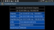
Map It! stands as a versatile navigation tool designed to simplify location-finding needs. Users are empowered to input an address or coordinates in various formats, including latitude/longitude in any notation, UTM (Universal Transverse Mercator), MGRS (Military Grid Reference System used by the USA and NATO), and Maidenhead (used by ham radio aficionados). Voice entry is also supported for added convenience.
Beyond its fundamental feature of pinpointing locations, the app embellishes the navigation experience by allowing users to determine the distance to any destination. Moreover, it facilitates the conversion between different coordinate systems with ease.
Immerse in an array of map types tailored to preferences: from immersive satellite/aerial imagery, informative topographic/terrain maps, to practical street views. For users seeking even more robust features, integration with Polaris Navigation GPS extends capabilities, offering valuable companion functionalities for anyone who requires precise location and mapping solutions.
Navigational needs and preferences vary greatly, and the software accommodates this diversity with its myriad of options and settings. The satellite imagery provides a clear and detailed overhead perspective, while topographic and terrain data are indispensable for outdoor adventures. Street views ensure that urban navigation is a breeze, engaging users with a familiar sight of the neighborhoods they traverse. It's the ideal combination of technology and user-centric design to support an efficient and comprehensive navigational tool.
For anyone who requires precise location and mapping solutions, Map It! is the ultimate resource to meet all navigational challenges effectively, making it an invaluable companion for exploration, travel, or any activity that involves finding one's way.
Requirements (Latest version)
- Android 5.0 or higher required










Comments
There are no opinions about Map It! yet. Be the first! Comment